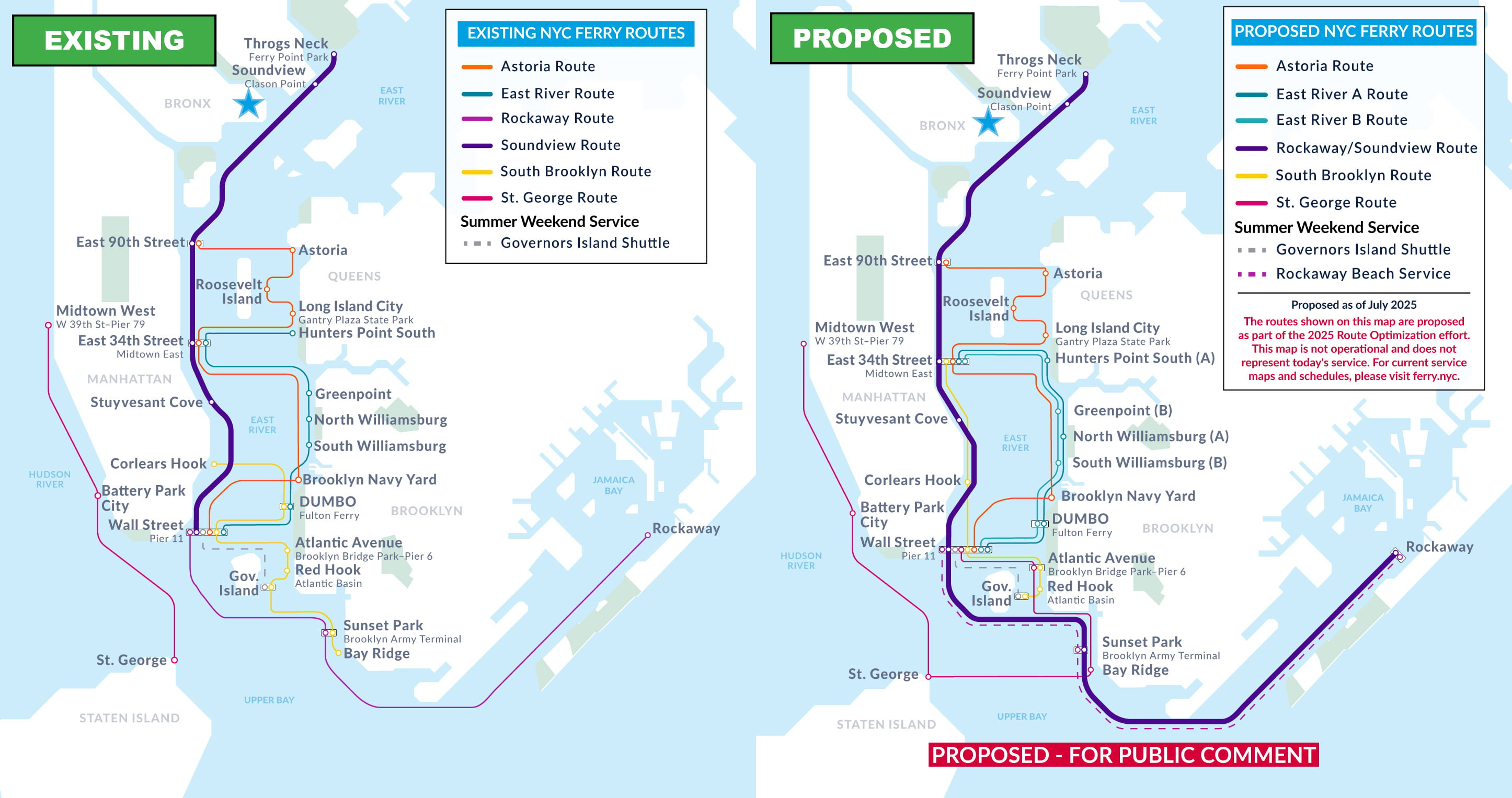
Proposed Changes by Landing

To learn more about how the 2025 Network Optimization may impact your trips, please select a landing below. Please note that service frequency and travel times are estimates and may be subject to change based on operations.
The Bronx
Ferry Point Park/Throgs Neck • Soundview/Clason Point
Brooklyn
Atlantic Ave/BBP Pier 6 • Bay Ridge • Brooklyn Navy Yard • DUMBO/Fulton Ferry • Greenpoint • North Williamsburg • Red Hook/Atlantic Basin • South Williamsburg • Sunset Park/BAT
Manhattan
Battery Park City/Vesey Street • Corlears Hook • East 34th Street • East 90th Street • Governors Island/Yankee Pier • Midtown West/West 39th Street-Pier 79 • Roosevelt Island • Stuyvesant Cove • Wall Street/Pier 11
Queens
Astoria • Hunters Point South • Long Island City • Rockaway
Staten Island
.
.
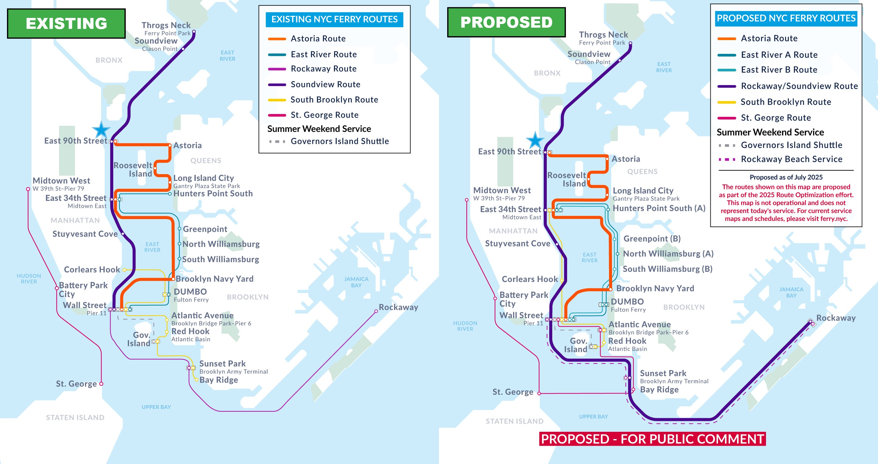
Ferry Point Park/Throgs Neck

New route added
Soundview and Rockaway routes will be combined (NEW!)
New direct connections
Will offer direct trips to Rockaway and Sunset Park/BAT (no transfer needed). Riders can still directly connect to Soundview, East 90th Street, East 34th Street, Stuyvesant Cove, and Wall St./Pier 11.
Service frequency change
Frequency will stay roughly the same. Ferry will arrive every 43 minutes during AM peak hours from 7am to 10am (was every 41 minutes).
Service Frequency (minutes between departures, by route) | ||
| Existing Soundview Route | Proposed RW-SV Route | |
| Weekday Peaks | 41 | 43 |
| Weekday Off-Peak | 61 | 64 |
| Summer Weekends | 45 | 45 |
Note: Peak period is from 7am -10am. Weekday and weekend schedules are seasonal.
.
Soundview/Clason Point
New route added
Soundview and Rockaway routes will be combined (NEW!)
New direct connections
Will offer direct trips to Rockaway and Sunset Park/BAT (no transfer needed). Riders can still directly connect to Ferry Point Park/Throgs Neck, East 90th Street, East 34th Street, Stuyvesant Cove, and Wall St./Pier 11.
Service frequency change
Frequency will stay roughly the same. Ferry will arrive every 43 minutes during AM peak hours from 7am to 10am (was every 41 minutes).
Service Frequency (minutes between departures, by route) | ||
| Existing Soundview Route | Proposed RW-SV Route | |
| Weekday Peaks | 41 | 43 |
| Weekday Off-Peak | 61 | 64 |
| Summer Weekends | 45 | 45 |
Note: Peak period is from 7am -10am. Weekday and weekend schedules are seasonal.
.
.
Atlantic Ave/BBP Pier 6
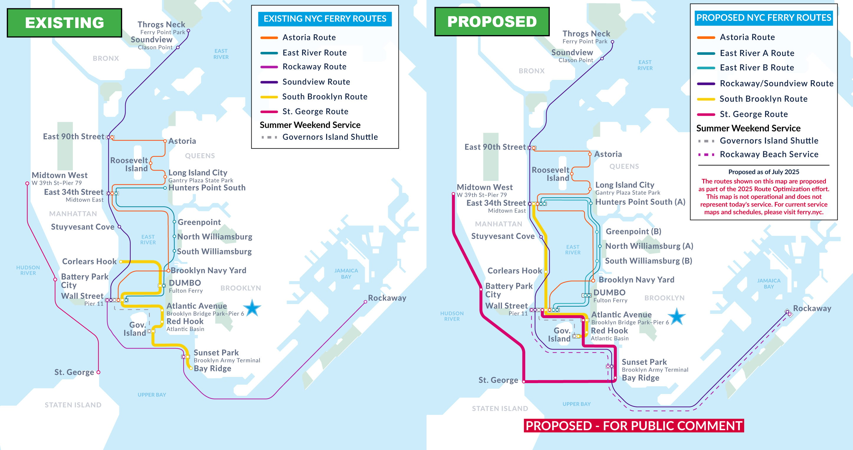
New route added
Will be served by two routes: South Brooklyn and St. George (NEW!)
New direct connections
Will offer direct trips to East 34th Street, Battery Park City/Vesey St., Midtown West/Pier 79, and St. George (no transfer needed). Riders can still directly connect to Bay Ridge, Governors Island/Yankee Pier, Red Hook/Atlantic Basin, Wall St./Pier 11, and Corlears Hook.
Service frequency improvements
St. George route ferry will arrive every 34 minutes and the South Brooklyn route ferry will arrive every 43 minutes during AM peak hours from 7am to 10am (is currently every 50 minutes on the South Brooklyn route).
Transfers for access to other landings
DUMBO/Fulton Ferry and Sunset Park/BAT will no longer be served by the South Brooklyn route. Riders may access these landings via a free transfer at Wall St./Pier 11.
Service Frequency (minutes between departures, by route) | |||
| Existing South Brooklyn Route | Proposed South Brooklyn Route | Proposed St. George Route (NEW!) | |
| Weekday Peaks | 50 | 43 | 34 |
| Weekday Off-Peak | 65 | 43 | 50 |
| Summer Weekends | 29 | 29 | 34 |
Note: Peak period is from 7am -10am. Weekday and weekend schedules are seasonal.
.
Bay Ridge
New direct connections
Will offer direct trips to St. George, Battery Park City/Vesey St., Midtown West/Pier 79 (no transfer needed). Riders can still directly connect to Atlantic Ave/BBP Pier 6 and Wall St./Pier 11.
Service frequency improvements
Ferry will arrive every 34 minutes during AM peak hours from 7am to 10am (was every 50 minutes).
Transfers for access to other landings
Bay Ridge will now be served by the St. George route instead of the South Brooklyn route. The St. George route will offer fast service to East and West sides of Manhattan. Riders may still access Governors Island/Yankee Pier, Red Hook/Atlantic Basin, Corlears Hook, and DUMBO/Fulton Ferry via a free transfer at Wall St./Pier 11.
Service Frequency (minutes between departures, by route) | ||
| Existing South Brooklyn Route | Proposed St. George Route (NEW!) | |
| Weekday Peaks | 50 | 34 |
| Weekday Off-Peak | 65 | 50 |
| Summer Weekends | 44 | 34 |
Note: Peak period is from 7am -10am. Weekday and weekend schedules are seasonal.
.
Brooklyn Navy Yard

There are no proposed changes to Brooklyn Navy Yard, but overall network improvements will add new connections.
Improved connectivity
Brooklyn Navy Yard will be one transfer away from St. George, Staten Island and the West Side, where currently there is no connection.
.
DUMBO/Fulton Ferry

Route changes
DUMBO/Fulton Ferry will be served exclusively by new East River A and East River B routes. These routes follow similar patterns to today’s East River route but with fewer stops and more frequent service. The South Brooklyn route will no longer serve DUMBO/Fulton Ferry.
Capacity improvements
Separating the existing East River route into two routes, East River A and East River B, with fewer stops on each means more seats are available on each trip when the ferry reaches DUMBO/Fulton Ferry.
Faster service
Since both the East River A and East River B routes will serve DUMBO/Fulton Ferry, riders will have faster travel times than they have today to East 34th Street, Hunters Point South, Greenpoint, and North Williamsburg.
Service frequency change
In peak periods, boats will depart approximately every 12 minutes between DUMBO/Fulton Ferry and Wall St./Pier 11. For service to other landings (South Williamsburg, North Williamsburg, Greenpoint, Hunters Point South), there will be service approximately every 24 minutes, similar to East River service today.
Transfers for access to other landings
The South Brooklyn route will no longer serve DUMBO/Fulton Ferry. Riders may still access Corlears Hook, Atlantic Ave/BBP Pier 6, Red Hook/Atlantic Basin, Governors Island/Yankee Pier, Sunset Park/BAT, and Bay Ridge via a free transfer at Wall St./Pier 11.
Service Frequency (minutes between departures, by route) | ||||
| Existing East River Route | Existing South Brooklyn Route* | Proposed ER A Route | Proposed ER B Route | |
| Weekday Peaks | 22 | 57 | 24 | 23 |
| Weekday Off-Peak | 36 | 57 | 36 | 36 |
| Summer Weekends | 18 | 29 | 24 | 23 |
*The South Brooklyn service to DUMBO will be discontinued; transfers available at Wall St/Pier.
Note: Peak period is from 7am -10am. Weekday and weekend schedules are seasonal.
.
Greenpoint

Route changes
Greenpoint will be served by the East River B route which will also serve Wall St./Pier 11, DUMBO/Fulton Ferry, South Williamsburg, and East 34th Street.
Capacity improvements
Separating the East River route into two routes, East River A and East River B, with fewer stops on each means more seats are available in both directions when the ferry reaches Greenpoint.
Faster service
Greenpoint will be a stop on the East River B route. Travel times to Wall St./Pier 11 will get faster by skipping North Williamsburg.
Service frequency change
Frequency will stay roughly the same, approximately every 24 minutes during AM peak hours from 7am to 10am.
Transfers for access to other landings
Riders may still access North Williamsburg and Hunters Point South via a free transfer at East 34th Street, DUMBO/Fulton Ferry, or Wall St./Pier 11.
Service Frequency (minutes between departures, by route) | ||
| Existing East River Route | Proposed ER A Route | |
| Weekday Peaks | 22 | 24 |
| Weekday Off-Peak | 36 | 36 |
| Summer Weekends | 18 | 24 |
Note: Peak period is from 7am -10am. Weekday and weekend schedules are seasonal.
.
North Williamsburg

Route changes
North Williamsburg will be served by the East River A route which still serves Wall St./Pier 11, DUMBO/Fulton Ferry, Hunters Point South, and East 34th Street.
Capacity improvements
Separating the East River route into two routes, East River A and East River B, with fewer stops on each means more seats are available when the ferry reaches North Williamsburg.
Faster service
North Williamsburg will be a stop on the East River A route. Travel times to DUMBO/Fulton Ferry and Wall St./Pier 11 will get faster by skipping South Williamsburg.
Service frequency improvements
Frequency will roughly stay the same, approximately every 23 minutes during AM peak hours from 7am to 10am (was every 22 minutes).
Transfers for access to other landings
Riders may still access South Williamsburg and Greenpoint via a free transfer at East 34th Street, DUMBO/Fulton Ferry, or Wall St./Pier 11.
Service Frequency (minutes between departures, by route) | ||
| Existing East River Route | Proposed ER B Route | |
| Weekday Peaks | 22 | 23 |
| Weekday Off-Peak | 36 | 36 |
| Summer Weekends | 18 | 23 |
Note: Peak period is from 7am -10am. Weekday and weekend schedules are seasonal.
.
Red Hook/Atlantic Basin

New direct connections
Now offers direct trips to East 34th Street (no transfer needed). Riders can still directly connect to Governors Island/Yankee Pier, Atlantic Ave/BBP Pier 6, Wall St./Pier 11 and Corlears Hook.
Service frequency improvements
Ferry will arrive every 43 minutes during AM peak hours from 7am to 10am (was every 50 minutes)
Transfers for access to other landings
The South Brooklyn route will no longer serve Sunset Park/BAT and Bay Ridge. Riders may still access these landings from Red Hook/Atlantic Basin via a free transfer at Wall St./Pier 11 or Atlantic Ave/BBP Pier 6.
Service Frequency (minutes between departures, by route) | ||
| Existing South Brooklyn Route | Proposed South Brooklyn Route | |
| Weekday Peaks | 50 | 43 |
| Weekday Off-Peak | 65 | 43 |
| Summer Weekends | 29 | 29 |
Note: Peak period is from 7am -10am. Weekday and weekend schedules are seasonal.
.
South Williamsburg

Route changes
South Williamsburg will be served by the East River B route, which will still serve Wall Street, DUMBO/Fulton Ferry, Greenpoint and East 34th Street.
Capacity improvements
Separating the East River route into two routes, East River A and East River B, with fewer stops on each means more seats are available when the ferry reaches South Williamsburg.
Faster service
South Williamsburg will be a stop on the East River B route. There will be a faster connection to East 34th Street by skipping North Williamsburg.
Service frequency change
Frequency will stay roughly the same. Ferry will arrive every 24 minutes during AM peak hours from 7am to 10am.
Transfers for access to other landings
Riders may still access North Williamsburg and Hunters Point South via a free transfer at East 34th Street, DUMBO/Fulton Ferry, or Wall St./Pier 11.
Service Frequency (minutes between departures, by route) | ||
| Existing East River Route | Proposed ER A Route | |
| Weekday Peaks | 22 | 24 |
| Weekday Off-Peak | 36 | 36 |
| Summer Weekends | 18 | 24 |
Note: Peak period is from 7am -10am. Weekday and weekend schedules are seasonal.
.
Sunset Park/BAT
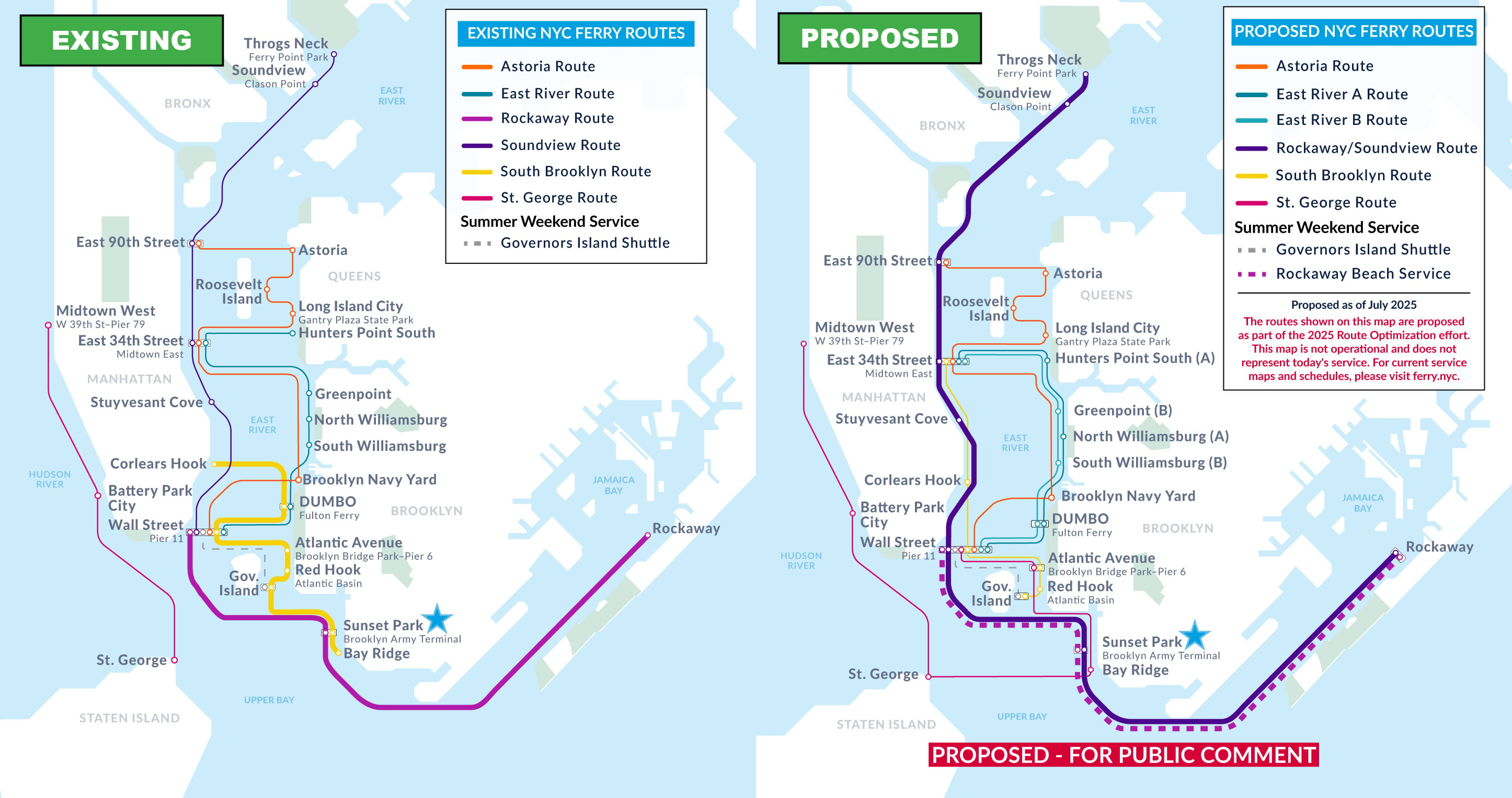
New routes added
Rockaway and Soundview routes will be combined (NEW!)
New direct connections
Will offer direct trips to Stuyvesant Cove, East 34th Street, East 90th Street, Soundview, and Ferry Point Park/Throgs Neck (no transfer needed). Riders can still directly connect to Rockaway and Wall St./Pier 11.
Service frequency improvements
Ferry will arrive every 43 minutes during AM peak hours from 7am to 10am (was every 64 minutes on the Rockaway route).
Transfers for access to other landings
Now exclusively served by the combined Rockaway/Soundview route, riders may still access Corlears Hook, DUMBO/Fulton Ferry, Atlantic Ave/BBP Pier 6, Red Hook/Atlantic Basin, and Bay Ridge via a free transfer at Wall St./Pier 11.
Service Frequency (minutes between departures, by route) | |||
| Existing Rockaway Route | Proposed RW-SV Route | Existing South Brooklyn Route | |
| Weekday Peaks | 64 | 43 | 50 |
| Weekday Off-Peak | 64 | 64 | 65 |
| Summer Weekends | 30 | 26 | 29 |
Note: South Brooklyn will not serve BAT/Sunset Park. Peak period is from 7am -10am. Weekday and weekend schedules are seasonal.
.
.
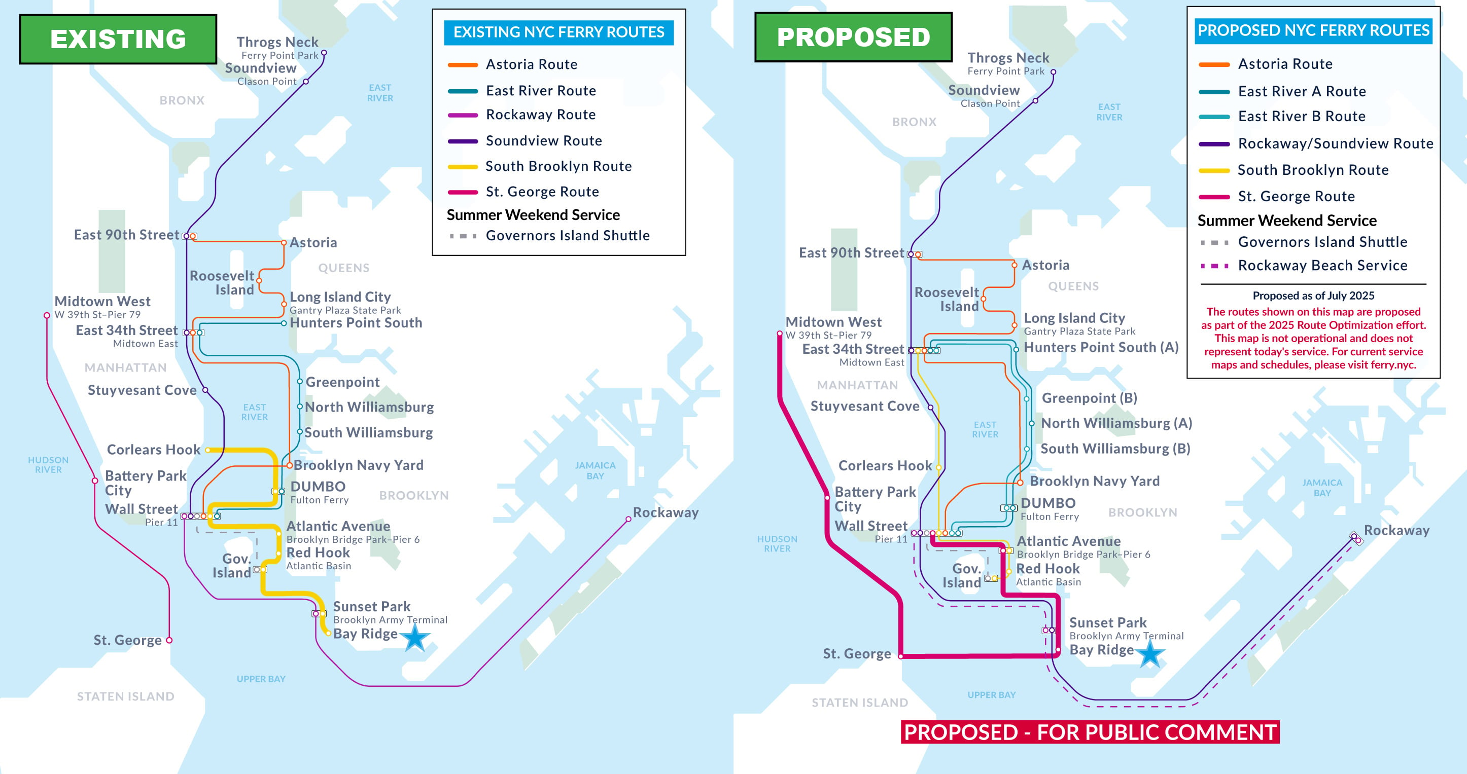
Battery Park City/Vesey Street

New direct connections
Will offer direct trips to Atlantic Ave/BBP Pier 6, Bay Ridge, and Wall St./Pier 11 (no transfer needed). Riders can still directly connect to Midtown West/Pier 79 and St. George.
Improved connectivity
Previously isolated from the rest of the network, riders will be able to reach any other NYC Ferry stop with just one free transfer.
Service frequency change
Ferry will arrive every 34 minutes during AM peak hours from 7am to 10am (was every 28 minutes).
Service Frequency (minutes between departures, by route) | ||
| Existing St. George Route | Proposed St. George Route | |
| Weekday Peaks | 28 | 34 |
| Weekday Off-Peak | 41 | 50 |
| Summer Weekends | 28 | 34 |
Note: Peak period is from 7am -10am. Weekday and weekend schedules are seasonal.
.
Corlears Hook

New direct connections
Will offer direct trips to East 34th Street (no transfer needed). Riders can still directly connect to Governors Island/Yankee Pier, Red Hook/Atlantic Basin, Atlantic Ave/BBP Pier 6, and Wall St./Pier 11.
Service frequency improvements
Ferry will arrive every 43 minutes during AM peak hours from 7am to 10am (was every 50 minutes).
Faster service
Will offer faster connection to Wall St./Pier 11 by bypassing DUMBO/Fulton Ferry on the South Brooklyn route.
Transfers for access to other landings
Riders may still access DUMBO/Fulton Ferry, Sunset Park/BAT, and Bay Ridge via a free transfer at Wall St./Pier 11.
Service Frequency (minutes between departures, by route) | ||
| Existing South Brooklyn Route | Proposed South Brooklyn Route | |
| Weekday Peaks | 50 | 43 |
| Weekday Off-Peak | 65 | 43 |
| Summer Weekends | 29 | 29 |
Note: Peak period is from 7am -10am. Weekday and weekend schedules are seasonal.
.
East 34th Street

New routes added
Will be served by five routes: Astoria, East River A, East River B, South Brooklyn (NEW!) and Rockaway/Soundview (NEW!)
New direct connections
Will offer direct trips to Rockaway, Sunset Park/BAT, Governors Island/Yankee Pier, Red Hook/Atlantic Basin, Atlantic Ave/BBP Pier 6, and Corlears Hook (no transfer needed). Riders can still directly connect to all the stops on the Astoria, East River, and Soundview routes.
Service frequency improvements
On the East River A and B routes, ferries to DUMBO/Fulton Ferry and Wall St./Pier 11 will depart approximately every 12 minutes. Service along the new South Brooklyn and Rockaway/Soundview route will also increase the number of departures toward Wall St./Pier 11.
Capacity improvements
The East River route is split into two routes: East River A and East River B. These routes will make fewer stops before reaching DUMBO/Fulton Ferry and Wall St./Pier 11, creating more available seats for riders.
Faster service
The East River A and East River B route will make fewer stops before reaching DUMBO/Fulton Ferry and Wall St./Pier 11, improving travel time to North Williamsburg, South Williamsburg, DUMBO/Fulton Ferry, and Wall St./Pier 11.
Service Frequency (minutes between departures, by route) | |||
| East River | Weekday Peaks | Weekday Off-Peak | Summer Weekends |
| Existing East River Route | 22 | 36 | 18 |
| Proposed ER A Route | 24 | 36 | 24 |
| Proposed ER B Route | 23 | 36 | 23 |
| Astoria | Weekday Peaks | Weekday Off-Peak | Summer Weekends |
| Existing Astoria Route | 38 | 57 | 37 |
| Proposed Astoria Route | 38 | 57 | 37 |
| Soundview | Weekday Peaks | Weekday Off-Peak | Summer Weekends |
| Existing Soundview Route | 41 | 61 | 40 |
| Proposed SV-RW Route (NEW!) | 43 | 64 | 45 |
| Rockaway | Weekday Peaks | Weekday Off-Peak | Summer Weekends |
| Existing Rockaway Route | - | - | - |
| Proposed SV-RW Route (NEW!) | 43 | 64 | 45 |
| South Brooklyn | Weekday Peaks | Weekday Off-Peak | Summer Weekends |
| Existing South Brooklyn Route | - | - | - |
| Proposed SB Route (NEW!) | 43 | 43 | 29 |
Note: Peak period is from 7am -10am. Weekday and weekend schedules are seasonal.
.
East 90th Street
New route added
Will be served by the Astoria route and an expanded Soundview-Rockaway route (NEW!)
New direct connections
Will offer direct trips to Rockaway and Sunset Park/BAT (no transfer needed). Riders can still directly connect to Astoria, Long Island City, Roosevelt Island, Brooklyn Navy Yard, Soundview, Ferry Point Park/Throgs Neck, East 34th Street, Stuyvesant Cove, and Wall St./Pier 11.
Service frequency change
On the expanded Soundview-Rockaway route, ferry frequency will stay roughly the same as the existing Soundview route with departures every 43 minutes during peak times. Astoria route frequency will remain the same.
Service Frequency (minutes between departures, by route) | |||
| Astoria | Weekday Peaks | Weekday Off-Peak | Summer Weekends |
| Existing Astoria Route | 38 | 57 | 38 |
| Proposed Astoria Route | 38 | 57 | 38 |
| Soundview | Weekday Peaks | Weekday Off-Peak | Summer Weekends |
| Existing Soundview Route | 41 | 61 | 45 |
| Proposed SV-RW Route (NEW!) | 43 | 64 | 45 |
| Rockaway | Weekday Peaks | Weekday Off-Peak | Summer Weekends |
| Existing Rockaway Route | - | - | - |
| Proposed SV-RW Route (NEW!) | 43 | 64 | 45 |
Note: Peak period is from 7am -10am. Weekday and weekend schedules are seasonal.
.
Governors Island/Yankee Pier

New direct connections
Will offer direct trips to East 34th Street (no transfer needed). Governors Island/Yankee Pier will continue to be served by a direct shuttle connection on summer weekends.
Service frequency improvements
Ferry will arrive every 43 minutes during AM peak hours from 7am to 10am (was every 50 minutes).
Transfers for access to other landings
Landings previously served by the South Brooklyn Route – DUMBO/Fulton Ferry, Sunset Park/BAT, and Bay Ridge —can be accessed from Governors Island/Yankee Pier via a free transfer at Wall St./Pier 11.
Service Frequency (minutes between departures, by route) | ||
| Existing South Brooklyn Route | Proposed South Brooklyn Route | |
| Weekday Peaks | 50 | 43 |
| Weekday Off-Peak | 65 | 43 |
| Summer Weekends | 29 | 29 |
Note: Peak period is from 7am -10am. Weekday and weekend schedules are seasonal.
.
Midtown West/W. 39th St.-Pier 79
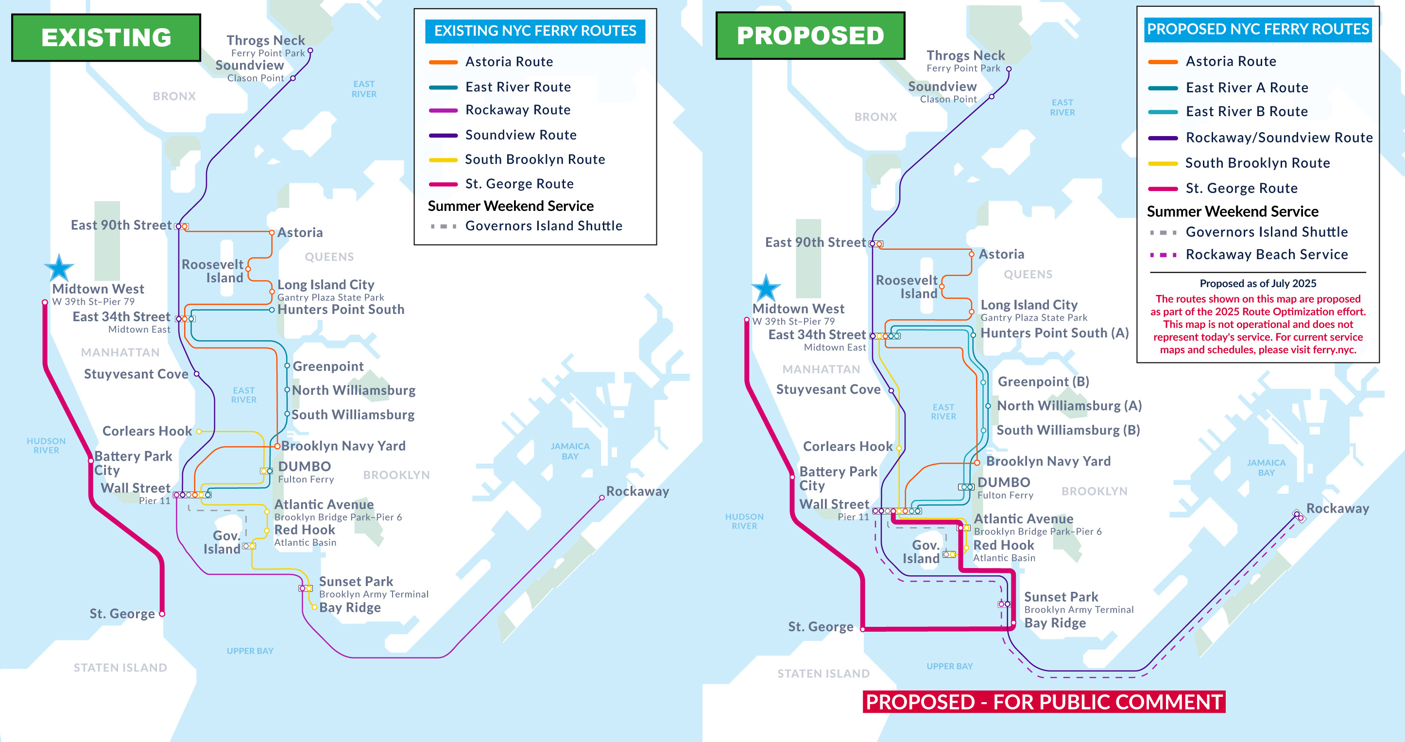
New direct connections
Will offers direct trips to Atlantic Ave/BBP Pier 6, Bay Ridge, and Wall St./Pier 11 (no transfer needed). Riders can still directly connect to Battery Park City/Vesey St., and St. George.
Improved connectivity
Previously isolated from the rest of the network, riders will be able to reach any other NYC Ferry stop with just one free transfer.
Service frequency change
Ferry now arrives every 34 minutes during AM peak hours from 7am to 10am (was every 28 minutes).
Service Frequency (minutes between departures, by route) | ||
| Existing St. George Route | Proposed Staten Island-Brooklyn Route | |
| Weekday Peaks | 28 | 34 |
| Weekday Off-Peak | 41 | 50 |
| Summer Weekends | 28 | 34 |
Note: Peak period is from 7am -10am. Weekday and weekend schedules are seasonal.
.
Roosevelt Island

There are no proposed changes to Roosevelt Island, but overall network improvements will add new connections.
Improved connectivity
Roosevelt Island riders will be able to transfer at Wall St./Pier 11 and access Staten Island and the West Side. This connection is not possible within the existing system.
.
Stuyvesant Cove

New routes added
Soundview and Rockaway routes will be combined (NEW!)
New direct connections
Will offer direct trips to Rockaway and Sunset Park/BAT (no transfer needed). Riders can still directly connect to Soundview, Ferry Point Park/Throgs Neck, East 90th Street, East 34th Street, and Wall St./Pier 11.
Service frequency change
Frequency will stay roughly the same. Ferry will arrive every 43 minutes during AM peak hours from 7am to 10am (was every 41 minutes).
Service Frequency (minutes between departures, by route) | ||
| Existing Soundview Route | Proposed RW-SV Route | |
| Weekday Peaks | 41 | 43 |
| Weekday Off-Peak | 61 | 64 |
| Summer Weekends | 45 | 45 |
Note: Peak period is from 7am -10am. Weekday and weekend schedules are seasonal.
.
Wall St/Pier 11
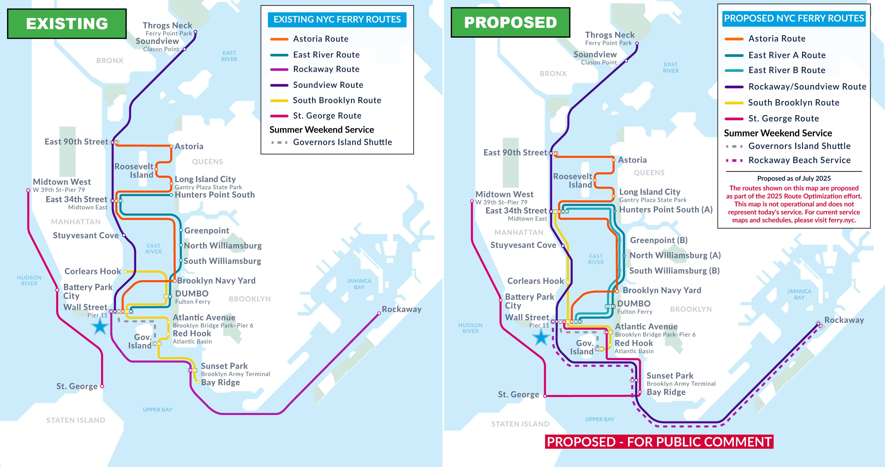
New routes added
Wall St/Pier 11 will become the true hub of the NYC Ferry system. With proposed changes, the landing will be served by all six routes: Astoria, East River, Rockaway, Soundview, South Brooklyn, and St. George (NEW!)
New direct connections
Will offer direct trips to Battery Park City/Vesey St., Midtown West/Pier 79, St. George (no transfer needed). Riders can still directly connect to all the stops on the Astoria, East River, Rockaway, Soundview, and South Brooklyn routes.
Service frequency improvements
Increased service frequency comes from multiple routes serving this stop.
Service Frequency (minutes between departures, by route) | |||
| East River | Weekday Peaks | Weekday Off-Peak | Summer Weekends |
| Existing East River Route | 22 | 36 | 18 |
| Proposed ER A Route | 24 | 36 | 24 |
| Proposed ER B Route | 23 | 36 | 23 |
| Astoria | Weekday Peaks | Weekday Off-Peak | Summer Weekends |
| Existing Astoria Route | 38 | 57 | 37 |
| Proposed Astoria Route | 38 | 57 | 37 |
| Soundview | Weekday Peaks | Weekday Off-Peak | Summer Weekends |
| Existing Soundview Route | 41 | 61 | 40 |
| Proposed SV-RW Route | 43 | 64 | 45 |
| Rockaway | Weekday Peaks | Weekday Off-Peak | Summer Weekends |
| Existing Rockaway Route | - | - | - |
| Proposed SV-RW Route | 43 | 64 | 32 |
| South Brooklyn | Weekday Peaks | Weekday Off-Peak | Summer Weekends |
| Existing South Brooklyn Route | - | - | - |
| Proposed SB Route | 43 | 43 | 29 |
| St. George | Weekday Peaks | Weekday Off-Peak | Summer Weekends |
| Existing St. George Route | 28 | 41 | 28 |
| Proposed Staten Island-Brooklyn Route (NEW!) | 34 | 50 | 34 |
Note: Peak period is from 7am -10am. Weekday and weekend schedules are seasonal.
.
.
Astoria

There are no proposed changes to Astoria, but overall network improvements will add new connections.
Improved connectivity
Astoria riders will be able to transfer at Wall St./Pier 11 and access Staten Island and the West Side. This connection is not possible within the existing system.
.
Hunters Point South

Route changes
Hunters Point South will be served by the East River A route which also serves Wall St./Pier 11, DUMBO/Fulton Ferry, North Williamsburg, and East 34th Street.
Faster service
Hunters Point South will be a stop on the East River A route. Travel times to North Williamsburg, DUMBO/Fulton Ferry, and Wall St./Pier 11 will get faster by skipping several stops.
Service frequency change
Frequency will stay roughly the same, approximately every 24 minutes during AM peak hours from 7am to 10am.
Transfers for access to other landings
Riders may still access South Williamsburg and Greenpoint via a free transfer at East 34th Street, DUMBO/Fulton Ferry, or Wall St./Pier 11.
Service Frequency (minutes between departures, by route) | ||
| Existing East River Route | Proposed ER B Route | |
| Weekday Peaks | 22 | 23 |
| Weekday Off-Peak | 36 | 36 |
| Summer Weekends | 18 | 23 |
Note: Peak period is from 7am -10am. Weekday and weekend schedules are seasonal.
.
Long Island City
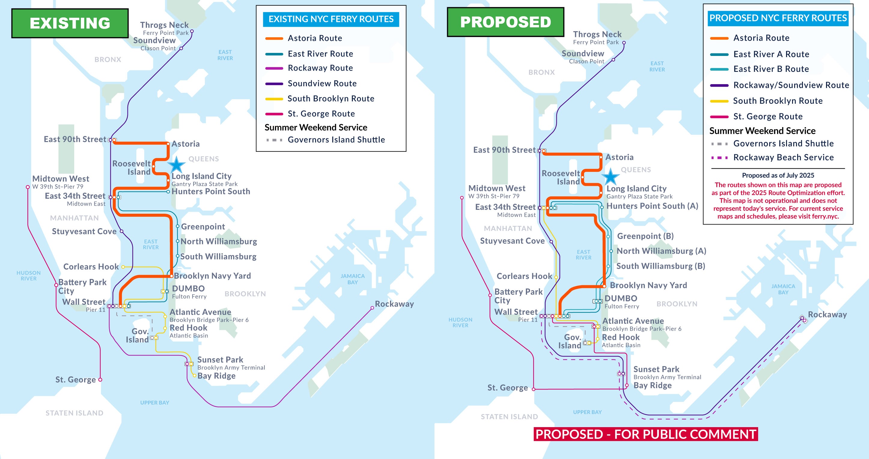
There are no proposed changes to Long Island City, but overall network improvements will add new connections.
Improved connectivity
Long Island City riders will now be able to transfer at Wall St./Pier 11 and access Staten Island and the West Side. This connection is not possible within the existing system.
.
Rockaway

New route added
Rockaway and Soundview routes will be combined (NEW!)
New direct connections
Will offer direct trips to Stuyvesant Cove, East 34th Street, East 90th Street, Soundview, and Ferry Point Park/Throgs Neck (no transfer needed). Riders can still directly connect to Sunset Park/BAT.
Service frequency changes
Ferry will arrive every 43 minutes during AM peak hours from 7am to 10am (was every 64 minutes). Connecting shuttle bus service will operate on both East and West routes during weekday peak periods only.
Summer Beach Service
Additional beach service will continue to operate from Wall Street/Pier 11 and Sunset Park/BAT on summer weekends and holidays.
Service Frequency (minutes between departures, by route) | ||
| Existing Rockaway Route | Proposed Rockaway Route | |
| Weekday Peaks | 64 | 43 |
| Weekday Off-Peak | 64 | 64 |
| Summer Weekends | 30 | 26 |
Note: Peak period is from 7am -10am. Weekday and weekend schedules are seasonal.
.
.
St. George

New direct connections
Now offers direct trips to Atlantic Ave/BBP Pier 6, Bay Ridge, and Wall St./Pier 11 (no transfer needed). Riders can still directly connect to Battery Park City/Vesey St. and Midtown West/Pier 79.
Improved connectivity
Previously isolated from the rest of the network, riders will be able to reach any other NYC Ferry stop with just one free transfer.
Service frequency change
Ferry will arrive every 34 minutes during AM peak hours from 7am to 10am (was every 28 minutes).
Service Frequency (minutes between departures, by route) | ||
| Existing St. George Route | Proposed Staten Island-Brooklyn Route | |
| Weekday Peaks | 28 | 34 |
| Weekday Off-Peak | 41 | 50 |
| Summer Weekends | 28 | 34 |
Note: Peak period is from 7am -10am. Weekday and weekend schedules are seasonal.